Medicine Lodge State Archaeological Site
4800 Road 52, Hyattville, WY 82428
PnUBpTMQ8D
![]()
OWNER: Wyoming State Parks
CONTACT: 307-469-2234
WEBSITE: http://wyoparks.state.wy.us/index.php/places-to-go/medicine-lodge
EVENTS: Events/Classes at this Park
Hours: 6:00 a.m. to 10:00 p.m.
GENERAL INFO:
Park Type: Conservation Area, Historic Site, State Park
Overall Size: Larger than a football field
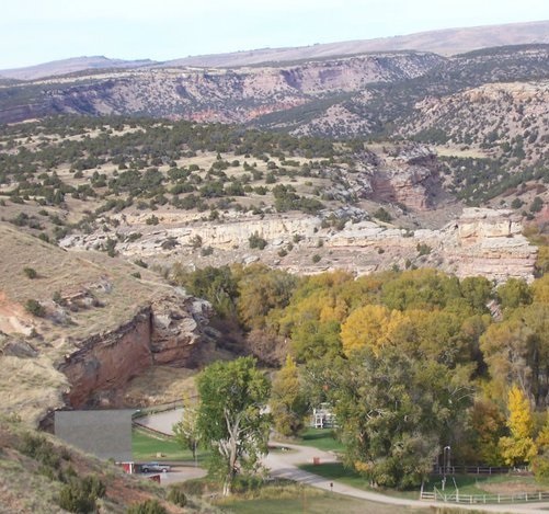
Special Features/Comments: More than 10,000 years of rich cultural history thrives at Medicine Lodge among the endless outdoor recreation opportunities. Wildlife viewing and opportunities for adventure are some of the best Wyoming offers. Discover why people have been returning here for more than 10,000 years. Come slow down and relax or speed up and explore.
GETTING THERE:
Parking
pDriving Directions: Medicine Lodge is located on the western slope of the Big Horn mountains in northern Wyoming. Take Highway 16/20 to Manderson and turn onto State Route 31. Travel 21 miles to Cold Springs Road, then Country Road 52 and follow the signs to the park. From Tensleep, take the Lower Nowood Road to State Route 31, then follow the signs to the park via Cold Springs Road and County Road 52
TADA Accessible: Yes
ACTIVITIES/RECREATION OPPORTUNITIES:
Open Space, Trails, Ice Skating, Horse Stables, Birdwatching, Fishing, Cross-country Skiing, Horseshoe Pits, ADA Accessible
AMENITIES:
General Park Amenities: Playground, Water/Spray Fountain, Restrooms, Drinking Fountains, Seating, Picnic Tables, Grills, ADA Accessible
Playground Size: Small
Playground Shade: Some
Playground Surface Type: Engineered wood fiber
Swimming: Natural Area (lake, beach)
Pets: Allowed On-Leash
Additional Features: Visitor Center, Nature Center, Historic Site, Picnic Shelter, Foot Bridge, ADA Accessible
Trash Cans: Yes
Camping: Tent, RV, Groups, Primitive, Youth Groups
Camping Amenities: Running Water, Overnight Camping, Fires Allowed, Fire Rings, Firewood Available, Grills, RV Hookups
TRAILS:
Trail Description: Explore this half-mile, self-guided walking trail through the park and along the bubbling creek. Several rest stops nestled in the trees offer shaded tranquility. Set your own pace and let nature be your guide. For a more rigorous hike try the Deer Path trail. This 1-mile loop follows actual deer paths that are moderately rugged and steep in some areas. Trail guides are available at the Deer Path trail head and at park headquarters.
Trail Surface: Paved & Unpaved
Trail Activities: Walking, Hiking, Running/Jogging, Skiing, Bicycling, Mountain Biking, Dog Walking, Birdwatching
Trail Difficulty: Easy
Trail Layout: Loop & Linear (network)
Trail Length: 0.5 to 1 mile
Trail Shade: Some
Trail Surface Type: Concrete, Gravel
Trail Slope: Flat/Gentle
Trail Width: 2-4 ft
Trail Extras: Kiosk with trail maps, Benches/Rest Areas, Panoramic Views, Historic Sites
OTHER:
Programming Available: Education/Ranger Programs
Park Information: Maps, Brochures, Information Kiosk, Available in language(s) other than English
Staffing & Safety: Employee/Ranger Present
Open Space Activities: Play frisbee or catch, Go for a walk or jog, Have a picnic, Do Yoga
Open Space Size: Larger than one football field in size
Open Space Shade: Some
Natural Water Feature: Creek/Stream
