Natural Bridge State Park
NB
6477 South Lee Highway, Natural Bridge, VA 24578
nUpMQ8D
OWNER: Virginia Department of Conservation and Recreation
CONTACT: (540) 291-1326
WEBSITE: http://www.dcr.virginia.gov/state-parks/natural-bridge#general_information
EVENTS: Events/Classes at this Park
GENERAL INFO:
Park Type: State Park
Overall Size: Larger than a football field
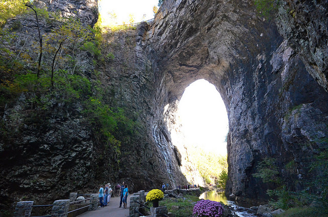
Special Features/Comments: Once owned by Thomas Jefferson and listed on the National Register of Historic Places, the 215-foot tall Natural Bridge is a limestone gorge carved out by Cedar Creek. The newest Virginia State Park is more than just the bridge. Beautiful forests, open, rolling meadows showcase the areau2019s karst terrain, and vistas of surrounding mountains and the James River valley display natureu2019s splendor. Access these via 6 miles of hiking trails, including the accessible Cedar Creek Trail that leads from the bridge to the Monacan Indian Village and Lace Falls with its 30-foot cascade. Living history programs connect you to the past and cover how people once used the areau2019s resources for survival and inspiration. Start at the visitor center where you will find exhibits and a gift shop.
GETTING THERE:
Parking
pDriving Directions: From I-81, take exit 175 or 180A to U.S. 11 and follow signs to the park.
Drive Time: Northern Virginia, three and a half hours; Richmond, two hours; Tidewater/Norfolk/Virginia Beach, four hours; Roanoke, 30 minutes.
ACTIVITIES/RECREATION OPPORTUNITIES:
Trails, Birdwatching, ADA Accessible
AMENITIES:
General Park Amenities: Restrooms, Drinking Fountains, Seating, Picnic Tables, Food for Sale, ADA Accessible
Pets: Allowed On-Leash
Additional Features: Visitor Center, Historic Site, Gift Shop, ADA Accessible
Trash Cans: Yes
Food for Sale Type: Snack Shop, Gift Shop
TRAILS:
Trail Description: More than 6 miles of hiking trails wind through the park providing a glimpse of nature. The Cedar Creek Trail is universally accessible and goes under the Natural Bridge to the Monacan Village, Lost River and Lace Falls. The nearly 2 miles of Buck Hill Trail and more than 3 miles of the Monacan Trail offer spectacular views of the Blue Ridge and Appalachian Mountains. Pack a lunch to take along and enjoy many scenic vistas. Cedar Creek Trail access beyond the bridge is limited during winter; call before arriving for details.
Trail Activities: Walking, Hiking, Running/Jogging, Bicycling, Dog Walking, Birdwatching
Trail Difficulty: Easy, Moderate
Trail Layout: Loop & Linear (network)
Trail Length: 5 to 10 miles
Trail Shade: Some
Trail Width: 8-12 ft
Trail Extras: Benches/Rest Areas, Panoramic Views, Historic Sites
OTHER:
Programming Available: Education/Ranger Programs, Junior Ranger Programs
Park Information: Maps, Brochures
Staffing & Safety: Employee/Ranger Present, Ranger Patrol
Open Space Activities: Go for a walk or jog, Have a picnic
Open Space Size: Larger than one football field in size
Open Space Shade: Some
Natural Water Feature: Creek/Stream
