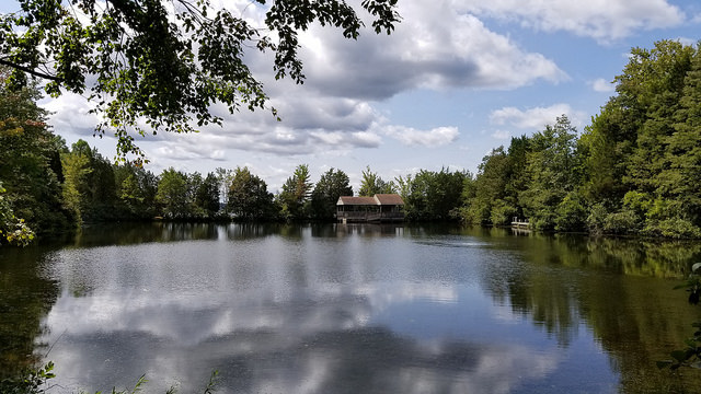
Lake Anna State Park
6800 Lawyers Rd., Spotsylvania, VA 22551

PnUpMQ8D
OWNER: Virginia Department of Conservation and Recreation
CONTACT: (540) 854-5503
WEBSITE: http://www.dcr.virginia.gov/state-parks/lake-anna#general_information
EVENTS: Events/Classes at this Park
GENERAL INFO:
Park Type: State Park
Overall Size: Larger than a football field
Special Features/Comments: The park has a beach on one of Virginia's most popular lakes, a fishing pond accessible to children and the disabled, a bathhouse-concessions complex and a boat launch. Overnight stays are made possible by camping, six camping cabins, two six-bedroom lodges and10 two-bedroom cabins. Seven cabins and the lodges have views of the lake. With more than 15 miles of trails, the park offers many hiking, biking and horseback riding options. Visitor center exhibits trace the history of the area's gold mining and highlight the park's natural features. Nature and gold panning programs are popular, and the park offers guided tours of the Goodwin Gold Mine. Note: Day-use parking areas near the beach and picnic areas fill up rapidly when the summer weather is nice on weekends and holidays. When this happens, park staff close the park road to additional traffic until enough parking spots have been vacated. Park closure may remain in effect until 4 p.m. We apologize for any inconvenience. Anglers may access the park's boat ramp as early as 5:30 a.m. Lights have been added to help with early and late boat ramp activity. An automatic gate allows campers to exit the boat ramp area and return to the campground after hours.
GETTING THERE:
Parking
pDriving Directions: The park lies adjacent to Route 601 off Route 208, 25 miles southwest of Fredericksburg and 60 miles northwest of Richmond. Drive Time: Northern Virginia, one hour; Richmond, one hour; Tidewater/Norfolk/Virginia Beach, three hours; Roanoke, four hours Directions: From I-95, take Exit 118 at Thornburg and travel about four miles on Rt. 606. At Snell, continue through the traffic light on Rt. 208. Stay on Rt. 208 west for 2 miles. At the stop light, continue straight for a short distance to another stop light. At this light, turn left onto Courthouse RD (Rt 208 west). Continue on Rt. 208 through the stop light at Spotsylvania High School. In 8 miles, turn right onto Rt. 601 Lawyers Road and drive 3 miles. You’ll see the state park sign on your left. Going east on I-64, take Exit 143 at Ferncliff and stay on Rt. 208 east for six miles. Go through Louisa and continue five more miles on 208 east to Mineral. Turn left at the traffic light, crossing railroad tracks. Take an immediate left onto Rt. 522 north and stay on the road for six miles to the intersection just before Dickinson Store. Take a right there onto Rt. (New Bridge Road) and travel eight miles. You’ll cross a bridge. When you get to Rt. 601 (Lawyers Road), turn left and go three miles. The park sign will be on your left. From west on I-64, take Exit 159 at Gum Springs. Take Rt. 522 north for 11 miles until you reach the village of Cuckoo. Stay on Rt. 522 until you reach Mineral. Turn right at the traffic light, crossing railroad tracks. Take an immediate left onto Rt. 522 north and stay on the road for six miles to the intersection just before Dickinson Store. Take a right there onto Rt. (New Bridge Road) and travel eight miles. You’ll cross a bridge. When you get to Rt. 601 (Lawyers Road), turn left and go three miles. The park sign will be on your left. Traveling south on Rt. 522, it’s best to go past the state park sign at the Rt. 612 intersection and, instead, stay on Rt. 522 for eight miles. At that point, you’ll see Dickinson Store. Turn left onto Rt. 208 east. Stay on that road for eight miles. You’ll cross a bridge. When you get to Rt. 601 (Lawyers Road), turn left and go three miles. The park sign will be on your left. Park Size
ACTIVITIES/RECREATION OPPORTUNITIES:
Open Space, Trails, Birdwatching, Fishing, Kayaking/Canoeing, Paddle Boarding, Marina/Boating
AMENITIES:
General Park Amenities: Playground, Restrooms, Drinking Fountains, Picnic Tables, Grills, Food for Sale
Playground Size: Medium
Playground Shade: Little or none
Playground Surface Type: Mulch
Swimming: Natural Area (lake, beach)
Pets: Allowed On-Leash
Additional Features: Visitor Center, Nature Center, Gift Shop, Picnic Shelter, Amphitheater, Bath House
Trash Cans: Yes
Food for Sale Type: Snack Shop
Camping: Tent, RV
Camping Amenities: Running Water, Overnight Camping, Fires Allowed, Fire Rings, Firewood Available, Grills, RV Hookups
TRAILS:
Trail Description: The park has 11 trails totaling more than 15 miles. All are for hiking with 12 miles designated as shared, multiple-use trails for hiking, biking and horseback riding. All trails also allow travel in both directions. They pass over moderate terrain through mixed hardwood and pine forest. All trails except Big Woods, Pigeon Run and Gold Hill trails are rated "easy," those three are rated more difficult. Click here (PDF) to download an Old Pond Trail guide published by Friends of Lake Anna State Park. Click here (PDF) to download a guide for the Railroad Ford self-guided trail.
Trail Activities: Walking, Hiking, Running/Jogging, Bicycling, Mountain Biking, Horseback Riding, Dog Walking, Birdwatching
Trail Difficulty: Easy, Moderate
Trail Layout: Loop & Linear (network)
Trail Length: Over 10 miles
Trail Shade: Some
Trail Slope: Flat/Gentle
Trail Width: 4-8 ft
Trail Extras: Kiosk with trail maps, Playground, Drinking Water, Panoramic Views
OTHER:
Programming Available: Education/Ranger Programs, Junior Ranger Programs
Park Information: Maps, Brochures
Staffing & Safety: Employee/Ranger Present, Ranger Patrol
Open Space Activities: Go for a walk or jog, Have a picnic
Open Space Size: Larger than one football field in size
Open Space Shade: Some
Natural Water Feature: Pond/Lake, Shoreline/Beach
