High Bridge Trail State Park
HB
6888 Green Bay Rd., Green Bay, VA 23942 (mailing address)
nUkTMQ8D
OWNER: Virginia Department of Conservation and Recreation
CONTACT: (434) 315-0457
WEBSITE: http://www.dcr.virginia.gov/state-parks/high-bridge-trail#general_information
EVENTS: Events/Classes at this Park
MANAGED BY: VA Dept of Conservation and Recreation Unknown
PARK SIZE: 0.03 Acres
HAS TRAILS: yes
GENERAL INFO:
Park Type: State Park
Overall Size: Larger than a football field
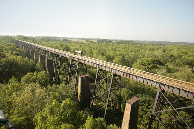
Special Features/Comments: High Bridge Trail is 31 miles long and ideally suited for hiking, bicycling and horseback riding. Once a rail bed, the trail is wide, level and generally flat. Its finely crushed limestone surface and dimensions make it easy to enjoy. The parku2019s centerpiece is the majestic High Bridge, which is more than 2,400 feet long and 125 feet above the Appomattox River. It is the longest recreational bridge in Virginia and among the longest in the United States. High Bridge, a Virginia Historic Landmark, is on the National Register of Historic Places. The trail is a National Recreation Trail recognizing exemplary trails of local and regional significance, connecting people to nature, to each other, and to our shared history and culture. Bring drinking water because none is available on the trail.
High Bridge access
There are two parking lots near High Bridge.
East of the bridge: Camp Paradise Rd.; Rice, Virginia (Prince Edward County)
Use 1681 Aspen Hill Rd., Rice, Virginia 23966, to get to the entrance of Camp Paradise Rd. then travel 1.5 miles to the parking area.
High Bridge is .3 miles from the Camp Paradise parking lot. Trailers are allowed in this lot, and equestrians may access the trail from it.
West of the bridge: River Rd., Farmville (Cumberland County)
Use 555 River Rd., Farmville, VA 23901, to get here. High Bridge is nearly a mile from the lot. Trailers are not allowed at this lot.
Trip suggestions
Bikers might prefer parking at the Rice parking lot, which is 3.1 miles from the bridge and 8 miles from Farmville. Bikers might also wish to park at the Main Street plaza parking lot in Farmville; the bridge is 4.5 miles from that lot.
For equestrians, the designated horse trailer parking lots are at Camp Paradise Rd. (3.2 miles from the bridge), Osborne Road (2.9 miles from the bridge) and Prospect (12.4 miles from the bridge).
GETTING THERE:
Parking
kParking Instructions: There are two parking lots near High Bridge.
East of the bridge: Camp Paradise Rd.; Rice, Virginia (Prince Edward County)
Use 1681 Aspen Hill Rd., Rice, Virginia 23966, to get to the entrance of Camp Paradise Rd. then travel 1.5 miles to the parking area.
High Bridge is .3 miles from the Camp Paradise parking lot. Trailers are allowed in this lot, and equestrians may access the trail from it.
West of the bridge: River Rd., Farmville (Cumberland County)
Use 555 River Rd., Farmville, VA 23901, to get here. High Bridge is nearly a mile from the lot. Trailers are not allowed at this lot.
Trip suggestions
Bikers might prefer parking at the Rice parking lot, which is 3.1 miles from the bridge and 8 miles from Farmville. Bikers might also wish to park at the Main Street plaza parking lot in Farmville; the bridge is 4.5 miles from that lot.
For equestrians, the designated horse trailer parking lots are at Camp Paradise Rd. (3.2 miles from the bridge), Osborne Road (2.9 miles from the bridge) and Prospect (12.4 miles from the bridge). State law requires that visitors carry a copy of a negative Coggins report with each horse brought to the park. Horses must be dismounted and led across bridges.
TADA Accessible: Yes
ACTIVITIES/RECREATION OPPORTUNITIES:
Trails, Birdwatching
AMENITIES:
General Park Amenities: Restrooms, Picnic Tables, Grills
Pets: Allowed On-Leash
Additional Features: Historic Site, Amphitheater, Foot Bridge, ADA Accessible
Trash Cans: Yes
TRAILS:
Trail Description: The linear park has more than a total of 40 miles of hiking, bicycle and bridle trails. High Bridge Trail, a recognized National Recreation Trail, itself is 31 miles long, and numerous additional biking and hiking trails adjacent to it.
Click here (PDF) for information about trail etiquette.
Hiking - Camp Paradise, Smyth, Spur Line and Spur Line Connector trails offer a variety of unique hiking experiences and are directly accessible from High Bridge Trail with easy to moderate difficulty.
Biking - Burnside, Deering and Early trails total 5.5 miles and offer fun and challenging single-track mountain biking. The Smyth Trail allows biking and hiking. Here's a map of those trails (PDF).
Trail Activities: Walking, Hiking, Running/Jogging, Bicycling, Mountain Biking, Single Track, Horseback Riding, Dog Walking, Birdwatching
Trail Difficulty: Easy, Moderate
Trail Layout: Loop & Linear (network)
Trail Length: Over 10 miles
Trail Shade: Some
Trail Width: 4-8 ft
Trail Extras: Kiosk with trail maps, Benches/Rest Areas, Mountain Biking Features
OTHER:
Programming Available: Education/Ranger Programs, Junior Ranger Programs
Park Information: Maps, Brochures
Staffing & Safety: Employee/Ranger Present, Ranger Patrol
Open Space Activities: Go for a walk or jog, Have a picnic
Open Space Size: Larger than one football field in size
Natural Water Feature: River/Channel
