Grayson Highlands State Park
GH
829 Grayson Highland Ln., Mouth of Wilson, VA 24363
nUpMQ8D
OWNER: Virginia Department of Conservation and Recreation
CONTACT: (276) 579-7092
WEBSITE: http://www.dcr.virginia.gov/state-parks/grayson-highlands#general_information
EVENTS: Events/Classes at this Park
GENERAL INFO:
Park Type: State Park
Overall Size: Larger than a football field
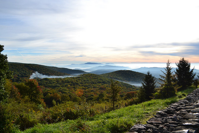
Special Features/Comments: Near Mount Rogers and Whitetop Mountain, Virginia's two highest mountains, Grayson Highlands offers scenic views of alpine-like peaks more than 5,000 feet high. Facilities include a visitor center, campgrounds, and hiking trails leading to waterfalls and overlooks. Scenic horse trails and a horse camping area with electric and water hookups, stables and parking for trailers are available. The park provides year-round access to the Appalachian Trail and the Virginia Highlands Horse Trail.
GETTING THERE:
Parking
pDriving Directions: The park is on U.S. 58 midway between Independence and Damascus and is reached from I-81 at Exit 45 in Marion; turn south on Route 16 and travel 24 miles to US 58 in the community of Volney. Turn right onto US 58. Travel eight miles to the park's entrance. Latitude, 36.628322. Longitude, -81.496889.
From I-77, take Hillsville Exit 14 to U.S. 58. Travel west on U.S. 58, 40 miles to Volney. Turn left to stay on U.S. 58 and go eight miles to the park entrance.
Its address is 829 Grayson Highland Lane, Mouth of Wilson, VA 24363; Latitude, 36.628322. Longitude, -81.496889.
Drive Time: Northern Va., 6.5 hours; Richmond, 5.5 hours; Tidewater, Norfolk, Virginia Beach, 7.5 hours; Roanoke, 2.5 hours; Winston-Salem, 1.5 hours; Charlotte, 1.5 hours; Raleigh, 4 hours
ACTIVITIES/RECREATION OPPORTUNITIES:
Trails, Horse Stables, Birdwatching, Fishing
AMENITIES:
General Park Amenities: Playground, Restrooms, Picnic Tables, Grills
Playground Size: Medium
Playground Shade: Some
Pets: Allowed On-Leash
Additional Features: Visitor Center, Nature Center, Historic Site, Gift Shop, Picnic Shelter, Amphitheater, Bath House
Trash Cans: Yes
Camping: Tent, RV, Groups, Primitive
Camping Amenities: Running Water, Fires Allowed, Fire Rings, Firewood Available, RV Hookups
TRAILS:
Trail Description: Hiking, bicycle trails (mountain bikes only), horse trails, self-guided trails.
Trail Activities: TRACK Trail, Walking, Hiking, Running/Jogging, Mountain Biking, Horseback Riding, Dog Walking, Birdwatching
Trail Difficulty: Easy, Moderate, Difficult
Trail Layout: Loop & Linear (network)
Trail Length: Over 10 miles
Trail Width: 4-8 ft
Trail Extras: Panoramic Views
OTHER:
Programming Available: Education/Ranger Programs, Junior Ranger Programs
Park Information: Maps, Brochures
Staffing & Safety: Employee/Ranger Present, Ranger Patrol
Open Space Activities: Go for a walk or jog, Have a picnic
Open Space Size: Larger than one football field in size
Natural Water Feature: Creek/Stream
