Belle Isle State Park
1632 Belle Isle Rd., Lancaster, VA 22503
nUpMQ8D
OWNER: Virginia Department of Conservation and Recreation
CONTACT: 804-462-5030
WEBSITE: http://www.dcr.virginia.gov/state-parks/belle-isle#general_information
EVENTS: Events/Classes at this Park
GENERAL INFO:
Park Type: State Park
Overall Size: Larger than a football field
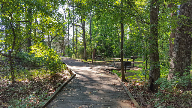
Special Features/Comments: Belle Isle has seven miles of shoreline on the Northern Neck's Rappahannock River and provides access to Mulberry and Deep creeks. The park lets visitors explore a wide variety of tidal wetlands interspersed with farmland and upland forests. It has a campground, three picnic shelters, hiking, biking and bridle trails, and motor boat and car-top launches. Belle Isle also offers overnight lodging at Bel Air and the Bel Air Guest House. Bicycle, canoe and kayak rentals are available. Guests also enjoy the park's universal access playground, boardwalk and fishing pier, and educational programs. The Bel Air historic area is ideal for weddings.
The diverse habitats found in the park provide homes to many predator birds, such as blue herons, osprey, hawks and bald eagles. White-tailed deer, turkeys, groundhogs, rabbits, squirrels, moles, reptiles and amphibians are also common. There are eight distinct types of wetlands within the park. These diverse ecosystems make Belle Isle an excellent outdoor laboratory for environmental education.
Please note that the city of Richmond, VA has a city park called Belle Isle. This is not the same park.
GETTING THERE:
Parking
pDriving Directions: Lancaster County on the Rappahannock River. From Warsaw, take State Route 3 East to SR 354. Turn right and follow for three miles. Turn right onto SR 683 at Somers to the park entrance. From Kilmarnock, take Route 3 West to Lively, then left on SR 201 for three miles, then right on SR 354 for three miles and left onto 683 to the park entrance.
Drive Time: Northern Virginia: two hours; Richmond: two hours; Tidewater/Norfolk/Virginia Beach: two hours; Roanoke: five hours
ACTIVITIES/RECREATION OPPORTUNITIES:
Trails, Birdwatching, Fishing, Kayaking/Canoeing
AMENITIES:
General Park Amenities: Playground, Restrooms, Drinking Fountains, Picnic Tables, Grills, ADA Accessible
Playground Size: Small
Playground Surface Type: Mulch
Pets: Allowed On-Leash
Additional Features: Visitor Center, Nature Center, Museum, Gift Shop, Picnic Shelter, Bath House, Rental Equipment
Trash Cans: Yes
Camping: Tent, RV, Groups, Primitive
Camping Amenities: Running Water, Fires Allowed, Fire Rings, Firewood Available, Grills, RV Hookups
TRAILS:
Trail Description: The park offers almost 10 miles of trails, most of which are gravel and multi-use. There are several short secondary trails around open fields. These areas are ideal places to observe songbirds, small mammals and butterflies. Osprey are plentiful along the walks in the spring and summer, and bald eagles may be seen in these areas in fall and winter months. There is also a short universally accessible boardwalk that wraps around Mulberry Creek near the car-top launch, and the fishing pier is a good place to observe waterfowl.
Trail Activities: Walking, Hiking, Running/Jogging, Bicycling, Mountain Biking, Horseback Riding, Dog Walking, Birdwatching
Trail Difficulty: Easy, Moderate
Trail Layout: Loop & Linear (network)
Trail Length: 5 to 10 miles
Trail Width: 4-8 ft
OTHER:
Programming Available: Education/Ranger Programs, Junior Ranger Programs
Park Information: Maps, Brochures
Staffing & Safety: Employee/Ranger Present, Ranger Patrol
Open Space Activities: Play frisbee or catch, Go for a walk or jog, Have a picnic
Natural Water Feature: River/Channel, Shoreline/Beach, Wetlands
