Heritage Trail Greenway
1.5 mile trail connects communities to natural spaces in the town of Newton - enjoy a walk, this TRACK TRAILS adventure (KidsInParks.com) is a fun activity in nature.
Near Carillon Assisted Living of Newton,1088 Radio Station Rd, Newton, NC 28658
nUBpkTMQ8D

OWNER: City of Newton Parks and Recreation
WEBSITE: http://www.newtonnc.gov/departments/recreation/greenways.php/
Hours: Open all seasons
GENERAL INFO:
Park Type: Green Space, Urban Park
Overall Size: Larger than a football field
Special Features/Comments:
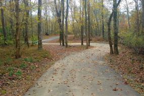
TRACK Trails Description: This paved 1.5 mile (one way) trail connects communities to natural spaces in the town of Newton. Whether you are commuting or simply enjoying a walk, the Heritage Trail Greenway Trail is easy way to get a dose of fun activity in nature.
See TRACK Trails MAP.
TRACK Trails Activities: Keep a lookout for deer, birds, and other animals that are attracted to the creek. The brochures provided at the trail will help you make the most out of your time on the greenway.
See TRACK Trails ADVENTURES - KidsInParks.com.
Register your visit with KidsinParks.com
LiveWell Catawba
GETTING THERE:
Parking
pDriving Directions: Trail end points: West 7th St. and North Carolina 10 W
kParking Instructions: Trail end points: West 7th St. and North Carolina 10 W
TADA Accessible: Yes
ACTIVITIES/RECREATION OPPORTUNITIES:
Trails, Birdwatching
AMENITIES:
General Park Amenities: Restrooms, Drinking Fountains
Pets: Allowed On-Leash
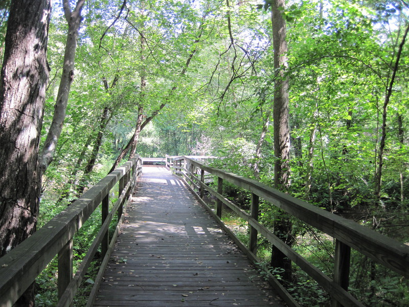
Additional Features: Foot Bridge
Trash Cans: Yes
TRAILS:
Trail Description: See TRACK Trails MAP. Location is HERE, See TRACK Trails ADVENTURES - KidsInParks.com, .
Many other PHOTOS from Google search. See SATELLITE Hybrid Photos.
See AllTrails Review, See Facebook Info. See Other Newton Neighborhood Parks
See Carolina Thread Trail Map, See Map of Future Plans , See Other TRACK Trails Nearby,
Adjacent 21 acre park at one end of the greenway: Newton Southside Park
Overview: If you're looking for the taste of the country without leaving the city, you and your family should walk the newly-completed Phase I & II of the Heritage Trail Greenway in Newton. Planned and created for the purpose of exercise, a mode of alternative travel, and connectivity of neighborhoods, the greenway allows residents to enjoy the sounds and beauty of nature while spending time outdoors with family and friends.greenway
Phase 1: The completed portion of Phase I of the greenway is located between West 7th Street and Radio Station Road near Carillon Assisted Living, measuring approximately 3/4 mile. Parking is available at the West 7th Street entrance. Phase I has been funded and constructed by the City, along with substantial donations from private property owners and developers who provided the rights-of-way to allow the project to proceed.
Phase 2: Phase II, which is located between Carillon Assisted Living and N.C. Highway 10 West, measuring approximately 3/4 mile. Phase II was funded by North Carolina Department of Transportation Enhancement Grant.
Greenway Distances:
Phase 1: 3/4 Mile one way (West 7th Street to Carillon Assisted Living)
Phase 2: 3/4 Mile one way (Carillon Assisted Living to Highway #10 West)
Total: 1.5 Miles
Trail Surface: Paved
Trail Activities: TRACK Trail, Walking, Running/Jogging, Bicycling, Dog Walking
Trail Difficulty: Easy
Trail Layout: Linear
Trail Length: 1 to 5 miles
Trail Shade: Some
Trail Surface Type: Asphalt
Trail Slope: Flat/Gentle
Trail Width: 4-8 ft
Trail Extras: Drinking Water
OTHER:
Park Information: Maps, Brochures, Information Kiosk
Staffing & Safety: Police Patrol
Open Space Activities: Go for a walk or jog
Open Space Size: Larger than one football field in size
Open Space Shade: Some
Natural Water Feature: Creek/Stream
