YMCA Camp Greenville
4399 YMCA Camp Road, Cleveland, SC 29635

nUBpQD

OWNER: YMCA Greenville South Carolina
CONTACT: 864-836-3291
WEBSITE: https://www.ymcagreenville.org/locations/ymca-camp-greenville
EVENTS: Events/Classes at this Park
Hours: Sunday: Closed
Monday: 8:30 am - 5:00 pm
Tuesday: 8:30 am - 5:00 pm
Wednesday: 8:30 am - 5:00 pm
Thursday: 8:30 am - 5:00 pm
Friday: 8:30 am - 5:00 pm
Saturday: Closed
GENERAL INFO:
Park Type: Conservation Area, Recreation Center/Facility, Special Use
Overall Size: Larger than a football field
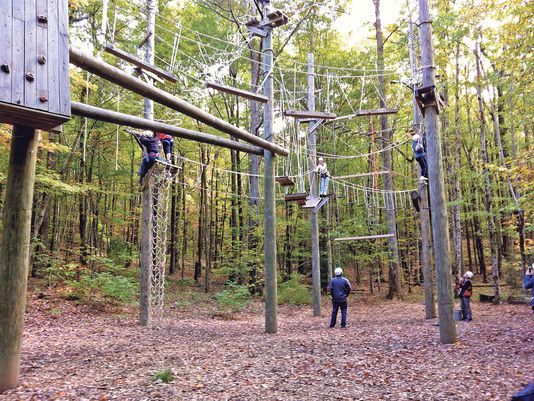
Special Features/Comments: Overnight Camp, Dining Hall, Adventure Center, Waterfalls, Hiking Trails, Indoor climbing wall, Zip line, Ropes Course
1,400 acres Camp Greenville is the 5th largest Y Camp in the country
Hosts family reunions, health and wellness retreats, church groups, university groups, Girl Scouts, Boy Scouts, Adventure Guides
Pretty Place Chapel
Cabins available
GETTING THERE:
Parking
pDriving Directions: From Greenville, South Carolina or Brevard, North Carolina, take Highway 276 towards the North Carolina/South Carolina state line. At the state line, turn at the YMCA Camp Greenville sign (left if you are coming from the North Carolina side, or right if you are coming from the South Carolina side.) Follow the road 4.5 miles into Camp Greenville u2013 the road actually dead ends at camp.
ACTIVITIES/RECREATION OPPORTUNITIES:
Gymnasium, Open Space, Trails, Birdwatching, Fishing, Rock Climbing Wall, Kayaking/Canoeing, Paddle Boarding, Archery, Music/Arts & Crafts, Observatory
AMENITIES:
General Park Amenities: Restrooms, Drinking Fountains, Seating, Food for Sale
Pets: Allowed On-Leash, Allowed Off-Leash
Additional Features: Nature Center
Trash Cans: Yes
Food for Sale Type: Restaurant
Camping: Youth Groups
TRAILS:
Trail Description: Set on the eastern ridge of the Blue Ridge Mountains, Camp Greenville provides excellent panoramic views of the South Carolina upstate area. On its southern side, the camp property adjoins Jones Gap State Park and the Mountain Bridge Wilderness Area u2013 opening up thousands of additional acres for recreational opportunities. Its northern property boundary is the North Carolina state line
Trail Surface: Unpaved
Trail Activities: Walking, Hiking, Running/Jogging, Mountain Biking, Horseback Riding, Dog Walking, Birdwatching
Trail Difficulty: Easy, Moderate, Difficult
Trail Layout: Loop & Linear (network)
Trail Length: Over 10 miles
Trail Shade: Lots
Trail Surface Type: Natural rock, Sand/Dirt
Trail Slope: Moderate
Trail Width: 4-8 ft
Trail Extras: Panoramic Views
OTHER:
Programming Available: Education/Ranger Programs
Staffing & Safety: Employee/Ranger Present
Natural Water Feature: Creek/Stream
