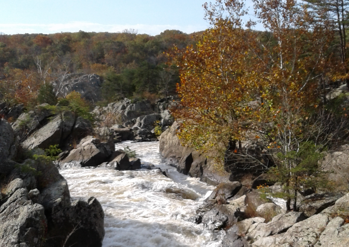
Chesapeake & Ohio Canal National Historic Park- Great Falls Tavern
11710 MacArthur Blvd, Potomac, MD 20854

nBpMQ8D
OWNER: National Park Service - Chesapeake & Ohio Canal National Historical Park
CONTACT: 301-767-3714
WEBSITE: https://www.nps.gov/choh/planyourvisit/greatfallstavernvisitorcenter.htm
EVENTS: https://www.nps.gov/choh/planyourvisit/
Hours: Dawn-Dusk
Visitor Center: open year round, Wednesday through Sunday from 9 AM to 4:30 PM. Closed Mondays and Tuesdays.
GENERAL INFO:
Park Type: Historic Site, National Park
Overall Size: Larger than a football field
Special Features/Comments: Billy Goat Trail Section A is very difficult rock climbing portion. Dogs are only allowed on certain trails, refer to signs or ranger.
GETTING THERE:
Parking
pDriving Directions: From Interstate 495:
Maryland: Take exit 41 (Carderock /Great Falls, MD), follow Clara Barton Parkway to the
end. At the stop sign, turn left onto MacArthur Blvd. Follow MacArthur approximately
3.5 miles into the park. MacArthur Blvd. ends at the park.
Virginia:
Cross into Maryland over the American Legion Bridge (beltway inner loop) and
take exit 41 (Clara Barton Parkway) Westbound, left at fork. Follow Clara Barton to the
end. At the stop sign, turn left onto MacArthur Blvd. Follow MacArthur Blvd
approximately 3.5 miles into the park. MacArthur Blvd. ends at the park.
From Washington DC:
Take M Street to fork. You can follow either MacArthur Blvd, the right fork or take Canal
Road, the fork to the left.
MacArthur Blvd.: Follow MacArthur until it ends at the entrance to the Great Falls
section of the park, approximately 8 miles.
Canal Road: Follow to Chain Bridge. At stop light continue straight ahead. Canal Road
changes into Clara Barton Parkway. Follow Clara Barton Parkway to the end. At the stop
sign, turn left onto MacArthur Blvd., and follow it for approximately 3.5 miles until it
ends at the park.
From Frederick, Maryland:
Follow Interstate 270 south toward Washington, DC. Take exit 5 (Falls Road). Exit right
toward Potomac on Falls Road. Follow Falls Road 6 miles until it intersects with
MacArthur Blvd.. At stop sign turn right into the park.
ACTIVITIES/RECREATION OPPORTUNITIES:
Open Space, Trails, Birdwatching, Fishing, Kayaking/Canoeing, Marina/Boating
AMENITIES:
General Park Amenities: Restrooms, Drinking Fountains, Seating, Picnic Tables
Pets: Allowed On-Leash
Additional Features: Visitor Center, Historic Site, Museum, Picnic Shelter
Camping: Tent
Camping Amenities: Running Water, Fires Allowed
TRAIL DESCRIPTION:
Trail Surface: Unpaved
Trail Activities: Walking, Hiking, Running/Jogging, Bicycling, Dog Walking
Trail Difficulty: Easy, Moderate, Difficult, Very Difficult
Trail Layout: Loop & Linear (network)
Trail Length: 5 to 10 miles
Trail Shade: Some
Trail Surface Type: Gravel, Natural rock, Sand/Dirt
Trail Slope: Flat/Gentle, Moderate, Steep
Trail Width: 2-4 ft, 4-8 ft
Trail Extras: Historic Sites
OTHER:
Programming Available: Education/Ranger Programs, Junior Ranger Programs
Park Information: Maps, Brochures, Information Kiosk
Staffing & Safety: Employee/Ranger Present
Open Space Activities: Have a picnic, Do Yoga
Open Space Size: Between basketball court and football field
Open Space Shade: Some
Natural Water Feature: Creek/Stream, River/Channel
